Hike in Short
| Metric | |
|---|---|
| Distance | 6,5 km |
| Altimeters | 570m |
| Time | 2h00m |
| Type | Return |
| Part of | - |
| Start/ End Location | Jägerstübli Lombachalp |
| End Location | Jägerstübli Lombachalp |
| Physical difficulty | medium |
| Technical difficulty | medium |
Hiking Map
Hike Report
Last year, we already published a hike on the Hardergrat ridge hike, where we went from Interlaken via the Harderkulm and Augstmatthorn to Habkern – a hike of 24 km and 1600 meters elevation. The full report, as well as more background information, can be found here. Having only limited time this year, we opted for a shorter and less intensive version, which does not compromise on the amazing view this hike offers.
This round-trip hike starts at the Jägerstübli Lombachalp, at 1560 meters, following the street 6 km uphill from Habkern. While buses are available from/ to Habkern, the Jägerstübli can only be reached by car with sufficient parking places there. Alternatively, a walking route is available from Habkern which will add 5 km with 500 meters of elevation to the tour.
During this hike, the incline starts right at the beginning. From the parking area, you enter a grassland which has an elevation after the first few hundred meters. Beware of the muddy parts which mostly are on/right next to the indicated route. To avoid wet shoes and slipping on the way up, it might be handy to deviate from the main path from time to time. Due to the wet and slippery sections, this hike is not recommended for wet days.

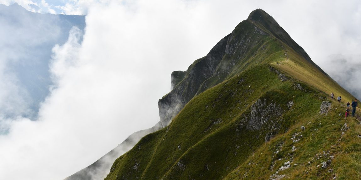
The total ascent is relatively steep with 500 meters of elevation in 2 km distance. As you approach the ridge from the north, you will have an idyllic view of green grasslands with cows, occasional forest sections and sporadic houses. Next to the grassland surface, you will encounter stony sections and very short forest ones. At the top of the ridge, you will directly see the clear turquoise colours of lake Brienz, surrounded by deep forst green hills on either side.

Instead of turning right for the continuation of the round-trip hike, we recommend to first go left for a few hundred meters to reach the Augstmatthorn peak at 2136 meters of elevation and enjoy the view on Brienz at the end of the east end of the lake. With good weather, the ridge also offers a view of the stunning mountain chain: Eiger, Mönch and Jungfrau. As the alpine hike session begins from the Augstmatthorn onwards, we headed back and continued to walk on the ridge in the direction of Interlaken.
While some sections are quite narrow, with deep drops on either side, most parts are wide enough to walk on without being uncomfortable. Be aware, however, that the ridge section can be quite busy with people coming from either direction and that proper shoes are a must! After a relatively flat section on the ridge, a small incline takes you to the Suggiture peak. From there onwards, the path changes to a rough gravel decline with narrow sections and turns.

For the last bit of the hike, you turn right after the decline from Suggiture, where you turn away from the ridge and the descent becomes more flat. The lake and mountain view are changed for the grassland again, with the Jägerstübli Lombachalp being already visible. The Jägerstübli changed of ownership in August 2020 and is now ran by two Swiss sisters: a perfect spot to have a hot chocolate, a coffee or a typical Swiss Suure Moscht. After a long straight section parallel to the mountain, you come back to the same route which takes you back to the parking.
Summing up, this hike is suitable for a wide range of hikers and groups of mixed levels. Due to the steep sections, it is challenging enough for experienced hikers, while the total length and elevation are doable for less experienced hikes too. Especially the ridge section is a reward for everyone with stunning views of the Berner Oberland. As mentioned before, the hike might be very crowded due to its popularity so be confident to also walk on the ridge while having to let people from the other direction pass.
Earned my respect i’m from Brazil, but i translated the text and loved it removed all my doubts finally found a good post on this subject, thanks.
Congratulations on the site, also know mine:
https://strelato.com
.