
Hike in Short
| Metric | |
|---|---|
| Distance | 13 km (8 miles) |
| Altimeters | 1,159m |
| Time | 5h30min |
| Type | One-way (15-min train to get back to Start) |
| Part of | Route 63 (Schwyzer Höhenweg) Etappe 3 |
| Start Location | Arth-Goldau Train Station, Switzerland |
| End Location | Sattel, Switzerland |
| Physical difficulty | medium |
| Technical difficulty | medium (primarly yellow paths) |
Hiking Map
Hike Report
Beautiful hike up from Arth-Goldau to Wildspitz peak at 1580m, providing astonishing views over the mountains in Luzern area, Zugersee and Lauerzersee. We were literally escaping clouds while climbing doing this in hike beginning of November 2020.
The hike starts at the train station of Arth-Goldau, where you can also park your car for 8 CHF for the full day at the Park & Ride spots of the station. The hike kicks off pretty easily and starts in the fore, pretty decent elevation rate. At the moment we were there, it was completely foggy so we cannot tell you anything about the view… Still, it was quite mystic all in all.

From there, the hikes bring you higher to a point where you overlook the Zugersee and Lauerzersee as well as the Swiss Alps on the background, beautiful spot for pictures. The elevation rate increases quite a bit from here, so strap up your boots and let’s prepare for some altimeters.
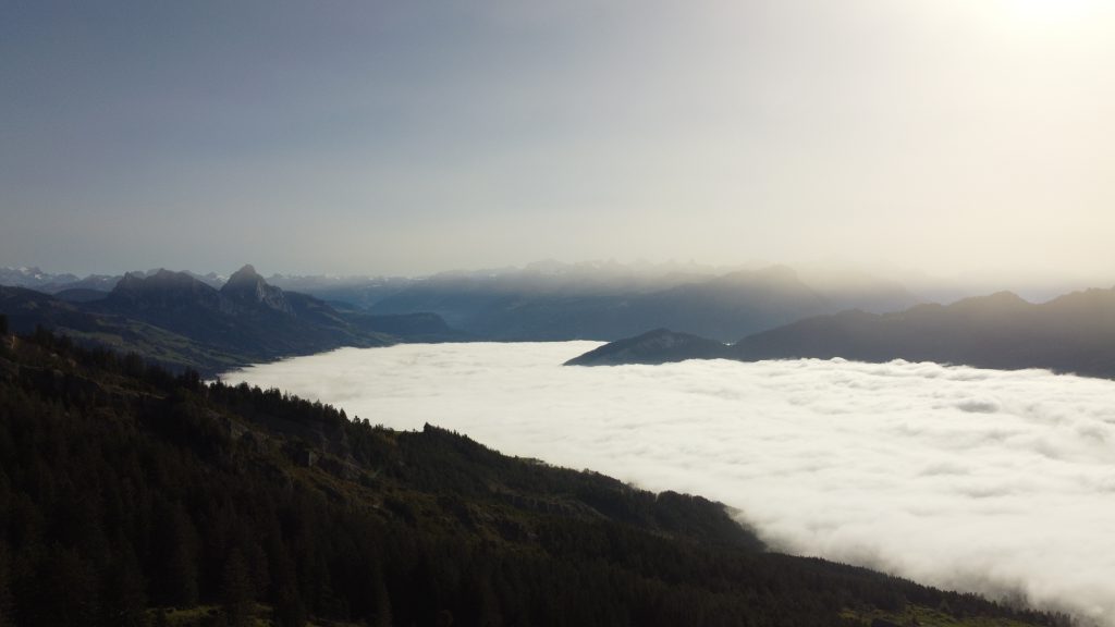
Although the hike takes you to Wildspitz, in reality you will get the best views at Gnipen which is at about the same altitude as the Wildspitz (±1560m). So make sure you take a stop there to get some pictures. If you reached Gnipen, to get to Wildspitz you will need to follow the path along a pretty broad ridge for another kilometer or so.


When you reached Wildspitz, you can follow the Route 63 down in the direction of Sattel (there are multiple ways to get there). We ended the hike at Sattel train station and took the train back to Arth-Goldau. The hike is part of Route 63 called the Schwyzer Höhenweg.
Video Journal
The video is a collection of the drone shots taken at the day we hiked up the Wildspitz, literally escaping the fog and clouds. For more drone and hike videos, you can go Videos.