Hike in Short
| Metric | |
|---|---|
| Distance | 23,5 km |
| Altimeters | 1,599m |
| Time | 8h30m |
| Type | One-way |
| Part of | ViaJacobi Stage 9 Brünigpass–Interlaken |
| Start Location | Interlaken Ost, Switzerland |
| End Location | Habkern, Switzerland |
| Physical difficulty | difficult |
| Technical difficulty | medium |
Hiking Map
Hike Report
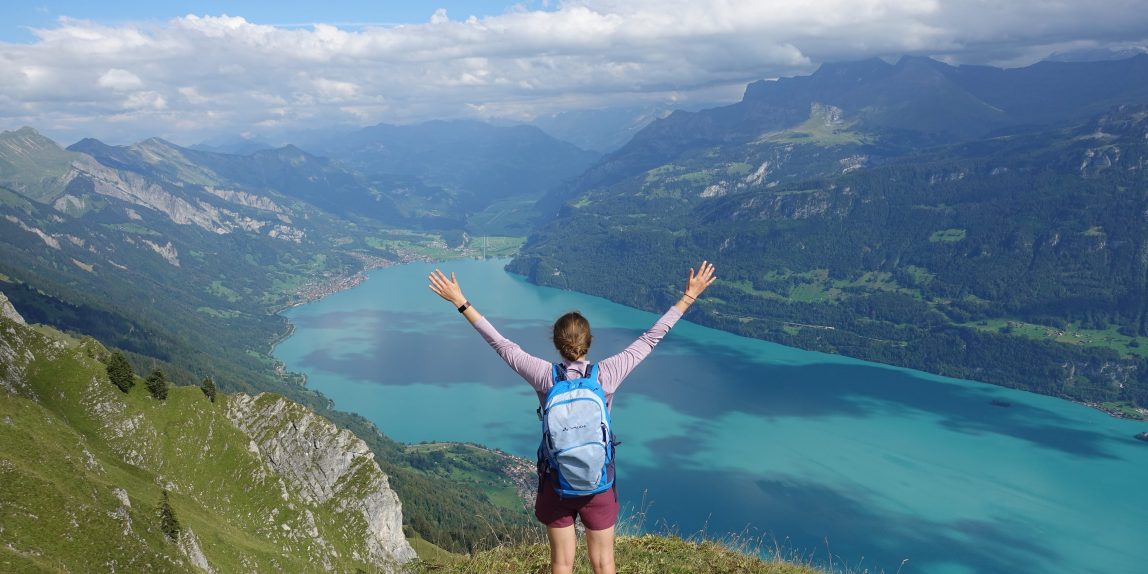
The Hardergrat trail is probably one of the most famous ridge hikes of Switzerland. While following the narrow path of the trail, you will be rewarded with a marvelous view on the turquoise-coloured Lake Brienz and the ridge before you. However, with a steep drop of around 1000-1500 m from the path to the Lake below you should be sure-footed and not afraid of heights. The full trails goes all the way from Interlaken to Brienz via the Harder Kulm, Augstmatterhorn and Brienzer Rothorn, amounting to 32 km, with 3000 meters ascent and descent, respectively. However, not having enough time for the whole trip when we did the hike in September 2020, we decided for a shorter round-trip version from Interlaken via Augstmatthorn to Habkern.
Starting at the Interlaken East train station, we got some nice views of the city while following the signs to the Harderbahn. If you want to skip the first incline and spend more time on the ridge, there is the option to take the train from here to the Harder Kulm. Instead, you can take the zig-zag path through the forest to pass the first 750 m to the plateau. In between, there will be options to see the flat city of Interlaken right between the 2 lakes and the surrounding mountains.

From the plateau, you will not reach the ridge or see the Lake Brienz for another while, so be patient. Instead, the path continues up through the forest and slightly wider grass-fields in the direction of Wannichnubel and Roteflue. The path is easy walkable here with a firm stony surface. Close to Schönbüel there are no more trees and you can finally see the full length of the Lake Brienz and with a bit of luck the peaks of Eiger, Mönch und Jungfrau on your right.

After another steep but final incline to Sugitture (2084 m) over stone, you will see the remainder of the trail stretching out before you: combined with the brilliant colours of green grasslands and forests, as well as the intensely blue lake, you will want to take a long pause here to relax and take in the beautiful landscape around you.
Following the narrow path, you will decrease slightly and continue going up and down a bit until reaching Augstmatterhorn. Instead of continuing our journey on the ridge trail, we took the path on the left to start the decline. As the actual time spend on the ridge was relatively short compared to the total ascent, we were sad to already say good-bye to the breathtaking view and already made plans for doing the whole trail next season. In other words, if you have the time (more than a day) or are a trail runner, and are up for a challenge, we would suggest to keep following the ridge hike.

The descent takes you through the very open green fields coming off of the ridge. While not seeing the lake anymore, the green landscape stretching in front of you have their own charm. Passing grazing cows and farms, the path gets broader compared to the ridge and will be more on grass than on stone. During the last few kilometers the path leads you straight over grass fields which are crossed by paved roads. Hence, if you prefer a steady surface, there is an option to take a slightly longer but paved and less steep route.

For the last part of trip, we took the bus 106 which brought us in 15 minutes from Habkern to the train station Interlaken West (~4 CHF). These 7 km could be walked, but with a path mostly following the main road and another 500 m decline, it is not recommended. Depending on our connection, you can either take the train from Interlaken West or take the chance to walk the last 1,5 km to the East station. By doing so, you will finish your hike with a nice stroll through the iconic city center of Interlaken with the Japanese Garden and maybe you will even spot some landing paragliders.
As a closing note, the Hardergrad trail is definitely unique and worthwhile to add to your bucket list. However, if you find the entire ridge section too long or scary, this hike option offers you a great combination between experiencing the ridge while spending the majority of the hike on easier sections. Additionally, the trains on each end of the ridge allow you to skip parts of the ascent or descsent.